Community maps are making waves across coastal India. Poor legal recognition of small-scale fishers’ customary rights to coastal and marine commons has spurred a grassroots mapping revolution, filling the void left by laws that govern India’s coast. After all, coasts are the lifeline of fishers—a place where they store boats and nets, dry fish, collect crabs and shells, or play a range of sports.
The Coastal Regulation Zone (CRZ) Notification, 2019, regulates development along the coast by zoning the entire coastline and marking where certain activities are restricted or prohibited. The State Coastal Zone Management Authority (CZMA), a state-level body established under the CRZ, maps out the coasts every five years and creates a Coastal Zone Management Plan (CZMP). Development along the coast is planned as per the CZMP and on the basis of the CRZ zonation shown on these maps.
In the absence of any other legal recognition of rights given to fishers over coastal lands, they turn to the CZMP maps. These maps are meant to be prepared at three levels—state, district, and village. In reality, only state and district CZMP maps are made. In the absence of detailed village-level maps, there is absolutely no way for fishers to identify if village commons such as the beachfront, fishing hamlets, and community centres have been accurately marked in state plans. Simply because of the scale at which district maps are prepared, fishers are often left searching in vain for their fishing villages on these maps.

Even when villages do figure on CZMP maps, coastal commons are absent altogether from them. Coastal commons can include areas such as mangroves, beaches, and coral reefs, where complex ‘plant–animal–environmental’ relationships play out. They are interface areas between the sea and the land, and are used by local communities in various ways. The absence of recorded commons in CZMPs can expose the commons to encroachment and alienation. Community mapping is a step forward to remedy the absence of village maps.
How did community mapping begin?
Counter mapping or community mapping of coastal commons began in response to the inadequacy of state-prepared CZMP maps. In 2008, the central and state governments proposed an elevated beach expressway that cut across the city of Chennai. The expressway was to be built over coastal commons that were being used in multiple ways by fisher communities. The CZMP maps prepared by the state would be used to approve project proposals on the commons. But the maps failed to reflect the existing customary and traditional use of these spaces by fishers.
In response to this and as a way to assert their rights over coastal commons, the fishers of Chennai began a process of self-mapping using GIS technology that captured their customary and traditional knowledge. The project was eventually scrapped, but it paved the way for Chennai fishers to advocate for their rights over the city’s coastal commons. The idea of preparing counter maps caught on quickly and, since 2010, many more fishing villages of Tamil Nadu have been mapping their own coastal commons.
However, women have often not been included in mapping processes and are also usually absent from related discussions on the governance of commons. Their contributions, needs, and priorities are thus overlooked. Dakshin Foundation’s Coastal Grassroots Fellowship, which was offered to neithal (coastal) women from small-scale fishing families, was started with a view to strengthen women’s place in coastal governance. The fellowship was first launched in 2021 with six women from Nagapattinam district of Tamil Nadu and six from Ganjam district in Odisha. Conducted over 12 months, the Coastal Grassroots Fellowship combined workshops for concept building with practice-based leadership exercises in governance and topics that were central to fisher lives.
Four fishing villages in Ramanathapuram (Ramnad) district of Tamil Nadu were selected as the site of the fellowship’s second edition. Women between the ages of 20 and 35 years, who had completed standard 12, were eligible to apply. The only other criteria for application was that the women should have an inclination to work for the well-being of their community. In response to the immediate need of the fisher villages, the fellowship was designed around the theme of commons and mapping. The 12 fellows worked closely with mentors, that is, senior women leaders from the area who guided them in their 12-month journey.


Beyond latitudes and longitudes: Mapping relationships
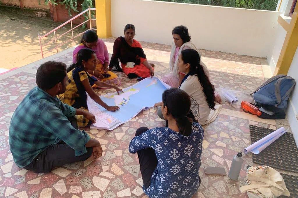
Since 2010, news of the Chennai fishers mapping their coast has inspired many fishing villages to map out their own coastal commons, an exercise that has slowly evolved into a fisher movement. A number of fishing villages in Ramnad too had mapped their coastal commons as a way to assert their rights over them. However, many of these maps had been made years ago and needed to be updated. In 2023, village leaders of the four villages of Ramnad, from where the fellows hailed, discussed updating their coastal maps and invited the fellows to participate in the process.
The fellows began by studying existing CZMP maps and reviewing earlier community mapping efforts. The existing village maps captured coastal commons using GIS technology, and were aligned with the state CZMP maps. While GIS maps have the advantage of capturing spatial information very well and are aligned with the maps of the state, they do not fully capture the essence of community commons, that is, the relationship between communities and their environment. In addition, GIS mapping demands a comfort with visualisation of material realities in a two-dimensional manner and requires specialised skills and knowledge of GIS tools and software, which itself can be a source of stress for lay people. All of this means that although villagers know the commons like the back of their hand, there is a gap between their understanding and the state’s understanding of it.
The fellows worked together to build new methods that drew on their own knowledge and social capital. They began with a blank canvas, going beyond the coastal commons and thinking about the village commons as a whole. They formulated an innovative ground-truthing exercise of ‘village walks and talks’, where they went on walks around the village and interviewed people they recognised as village experts or individuals holding knowledge. They also made sure to identify coastal commons frequented by women and children that might have been absent from the existing village coastal maps. An overlooked patch of mangroves in one place, a missing temple, a missing reference to a regularly used beach playground or a school were added to the list, with lively narratives of how they have been used over generations.
The fellows’ observations, photo evidence, and oral histories documented through interviews with the elderly members of the community enlivened the community maps with the dimension of time and community relationships. These nuances became a focal point for engaging debates and discussions, highlighting points of concern or conflict. For instance, Thaneerootru village marked out a health centre and dispensary run by a local charitable trust, a place the women of the village relied on to address the health needs of their families. They traced its history back to a time when the villagers had willingly handed over a parcel of their village common land to the charitable trust to run a health centre. This stimulated an interesting debate among the fellows—around questions of ownership and purpose served by the commons. The fellows mutually agreed that they needed more information to be sure of the history of the health clinic; they were also firm in their belief that commons that had been collectively handed over by a community to a private party in the community’s interest should continue to be considered community commons.
A new understanding of commons as well as of women’s roles
The women’s departure from earlier community mapping methodologies meant that the commons were being seen as more than latitudes and longitudes marked out on paper. They revealed a deeper understanding of the essence of the commons, which lay in relationships among its users—humans, animals, and plants—of the past and present; these are details that slip through conventional maps. The fellows updated the maps, and not only reinserted missing pieces, such as overlooked mangroves and sandy beaches, but also weaved these into their collective lives, through locally collected family photographs, interviews, and public exhibitions. The maps became a journey of self-learning. Sathya Evangaline, a teacher and fellow, recalls their mapping of the Thaneerootru village commons, “Although I am from the fishing community, I didn’t even know the names of all the fish we caught. Now I do,” she says.
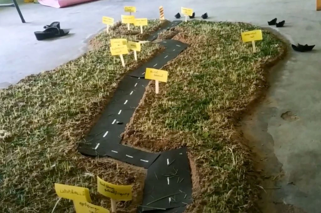
Community commons are kept alive by constant and repeated interaction among its users, bringing about new dimensions of relationships between users and their resources. The fellows organised exhibitions and invited the entire village to engage with their maps. Olaikuda village fellows designed another detailed village map made wholly with sand and tiny sprouts of millet seeds to complement the two-dimensional ones. Fellows from Karangad village used a mosaic of large hand-drawn maps that captured the different parts of the village. These maps of commons were showcased at the exhibition curated by the fellows, and photos and essays on the diverse fishing practices at these sites were displayed. Villagers, elders, and leaders gathered around the maps, asking questions, identifying areas they were most familiar with, sharing anecdotes, and suggesting small tweaks and changes or details to be added to the maps. Engaging with the commons has deepened the fellows’ relationships with the space, laying the foundation for informed leadership.
Walking through the village itself was an illuminating journey for the fellows. The Karangad fellows learned about the richness and biodiversity of the mangroves that surrounded their village while walking with an older member of the oor panchayat (the traditional fishing panchayat). But it had to be done during the day, and it was a strenuous activity to carry out in the heat. Requesting time from community members and explaining to them the idea behind the mapping exercise, conducted by women, was not an easy task either. Mixed in with the questions about gender roles—that is, why women had chosen to work outside of the house—were also questions about the usefulness of the process itself and where it would lead them. These were questions that the fellows did not have a clear answer to either as they were just starting out, and the methodologies were new to them and evolving with the process. But the mapping exercise helped prepare them to take on more active roles within the community.
Participating in governance
Mapping gave the fellows an inroad into the world of governance of coastal commons. Coastal commons and fishing practices in Tamil Nadu are governed by the oor panchayats. Traditionally, the oor panchayat comprises male fishers only. The fellows requested an audience with them to present the list of places to be included in the village coastal maps. Presenting before an all-male oor panchayatwas daunting for them. “There has never been a place for women in an oor panchayat meeting,” Nesiyal, a fellow from Thaneerootru village, explained, drawing attention to the general exclusion of women from key governance spaces. When Muthulakshmi from Morepannai village found it difficult to put forth her points effectively at the oor panchayat meeting, Jerald Mary, a community mentor to the fellows, stepped in for her.
The fellowship was also designed to give the women public exposure—from conducting interviews of community members they were not familiar with to participating in district events. Additionally, the fellows organised and curated village-level exhibitions to showcase the work—ranging from photographs to mapping—that they had done as part of the fellowship. This has resulted in increased confidence in their knowledge and ability to handle challenging work. Over time, the fellows have begun to demand space for themselves in the ecosystem of governance. For instance, in Karangad village, a committee of male members was formed to update the maps of the village commons. The fellows noticed the absence of women in the original composition of the committee and were keen to remedy this. They approached the village leaders and asked to be included in the committee, and now participate actively in regular meetings of the committee.
They are also more confident in their collective leadership, and the vision for the future is clear for these women leaders even as they are constantly learning. Muthulakshmi shares, “I had never gone out to the sea. I did this for the first time to take photographs of fishing practices!” Gerald Mary, who mentored six fellows from Karangad and Morepannai villages, says of her own cohort and other women in the village, “Women should be able to speak in public and have equal membership in a village meeting or a public meeting.” Talking of true inclusion, she adds. “There is a 33 percent mandated reservation for elected posts, but what we need is real and effective participation and involvement of women (at all levels).”
—
Know more
- Read this article to know what panchayats can do to conserve commons.
- Read this study to learn more about the polycentric approach to commons governance.